View Larger Map
Map of Shropshire | Local Search for Attractions & Services
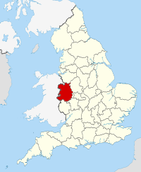
Use the interactive tourist map of Shropshire to search for a range of local attractions, services and amenities. The county of Shropshire is located in the West Midlands, the county is known for its landscape, the quiet countryside that is a haven for walkers and enthusiasts of the great outdoors. The country retains much of its historic charm with scenic towns and charming villages. Shropshire includes a number of historic houses, museums, gardens and attractions including the famous Ironbridge Gorge site, a world heritage site. The county includes a number of attractions for visitors to explore, including a range of historic and family attractions.
Search for Shropshire restaurants, cafes, coffee shops, bars, tourist information, visitor attractions including museums, art galleries, historic houses, cinemas, theatres, places of interest and much more. Use the map to better plan your trip to Shropshire using the useful interactive tourist map, learn more about the county and the range of tourist attractions the county has to offer.
The map includes a location and area map of Shropshire along with street view. Use the map to:
- Find directions for driving, walking, bicycling and public transport.
- Use the search function to find local attractions, dining, entertainment, services and amenities.
- Use the layers on the map to find information on local weather and forecast, travel information including traffic conditions showing the latest traffic flow and congestion.
- The photos layer includes photos relating to the map area from panoramio.
- The Distance tool shows a distance radius around a point on the map and can be used to calculate the distance between two points on the map.
Notable local attractions in Shropshire include: Shropshire Hills, (AONB), Shrewsbury Castle, Shrewsbury Abbey, Wroxeter Roman City, Telford Steam Railway, Attingham Park, Hoo Farm, Royal Air Force (RAF) Museum Cosford and Ironbridge Gorge - World Heritage Site.
Local towns in Shropshire include: Telford, Shrewsbury, Oswestry, Newport, Bridgnorth, Ludlow and Market Drayton.
English Counties sharing a border with Shropshire include: Cheshire, Herefordshire, Staffordshire and Worcestershire. Shropshire also has a western border with Wales.
To view the interactive Shropshire maps please see: Map of Shropshire - Local Search Map
Disclaimer: The information given in on this website is given in good faith and to the best of our knowledge. If there are any discrepancies in no way do we intend to mislead. Important travel details and arrangements should be confirmed and verified with the relevant authorities.