View Larger Map
Map of Kent | Local Search for Attractions & Services
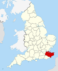
Use the interactive tourist map of Kent to search for a range of local attractions, services and amenities. The county of Kent is located in south east England, known for its hop and orchard gardens, it is often referred to as the ‘Garden of England’. Kent includes plenty of coastline with a number of scenic coastal towns and villages along with seaside resorts including Folkestone, Margate, Dover and Whitstable. The county includes a number of areas of scenic English countryside, open spaces and a number of historic houses, museums, gardens and attractions including Leeds Castle, Canterbury Cathedral and the famous White Cliffs of Dover. The county includes a number of attractions for visitors to explore, including a range of historic and family attractions.
Search for Kent restaurants, cafes, coffee shops, bars, tourist information, visitor attractions including museums, art galleries, historic houses, cinemas, theatres, places of interest and much more. Use the map to better plan your trip to Kent using the useful interactive tourist map, learn more about the county and the range of tourist attractions the county has to offer.
The map includes a location and area map of Kent along with street view. Use the map to:
- Find directions for driving, walking, bicycling and public transport.
- Use the search function to find local attractions, dining, entertainment, services and amenities.
- Use the layers on the map to find information on local weather and forecast, travel information including traffic conditions showing the latest traffic flow and congestion.
- The photos layer includes photos relating to the map area from panoramio.
- The Distance tool shows a distance radius around a point on the map and can be used to calculate the distance between two points on the map.
Notable local attractions in Kent include: Canterbury Cathedral and St Augustine's Abbey in Canterbury part of the UNESCO World Heritage Site, Leeds Castle, Dover Castle, Tunbridge Wells Museum and Art Gallery, Knole, Ashford Designer Outlet, The White Cliffs of Dover and Chartwell House.
Local cities and towns in Kent include: City of Canterbury, Dover, Rochester, Maidstone, Folkestone and Tunbridge Wells
English Counties sharing a border with Kent include: East Sussex, Essex, Greater London and Surrey
To view the interactive Kent maps please see: Map of Kent - Local Search Map
Disclaimer: The information given in on this website is given in good faith and to the best of our knowledge. If there are any discrepancies in no way do we intend to mislead. Important travel details and arrangements should be confirmed and verified with the relevant authorities.