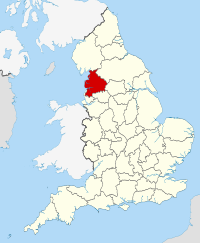
Exploring Lancashire Maps: A Journey Through History, Landscape, and Cartography
Exploring Lancashire through its maps offers a fascinating glimpse into the county’s rich history and diverse landscapes. From the bustling cities of Manchester and Liverpool to the serene countryside of the Ribble Valley, Lancashire’s maps reveal a tapestry of cultural and geographical wonders.
As we delve into these maps, we uncover the stories of ancient settlements, industrial revolutions, and natural beauty. Whether we’re history buffs, geography enthusiasts, or simply curious travellers, Lancashire’s maps provide a unique lens through which we can appreciate this vibrant region. Join us on a journey through time and space as we navigate the intricate details of Lancashire’s cartographic treasures.
Key Takeaways
- Historical Significance: Lancashire maps provide insights into the county’s evolutionary journey from medieval settlements to modern urban centres, highlighting key historical transformations.
- Types of Maps: Different types of Lancashire maps, such as topographic, historical, and modern digital maps, serve various purposes, from illustrating natural features to offering real-time navigation.
- Key Features: These maps underscore significant geographic highlights and notable landmarks, such as the Forest of Bowland, Lancaster Castle, and Blackpool Tower, emphasising the region’s diverse landscape and rich heritage.
- Collecting Maps: Collecting Lancashire maps involves understanding their historical value, verifying authenticity, and ensuring proper preservation. Resources include local archives, libraries, museums, and online databases.
- Modern Uses: Even in the digital age, Lancashire maps are crucial for recreational and educational purposes. They aid hikers, bikers, educators, and students, enhancing various activities and learning experiences.
History Of Lancashire Maps
Lancashire’s maps tell the captivating story of its development over the centuries. From early representations to more detailed modern maps, we see how the region has transformed.
Early Lancashire Maps
The earliest maps of Lancashire date back to the medieval period. These maps, often rudimentary and hand-drawn, provided basic geographic information without much detail. They served primarily for administrative purposes, indicating land boundaries and property ownership.
John Speed’s map from 1610 is one of the most notable early maps. It offers a glimpse into the county’s layout during that period, showcasing towns, forests, and roads. Rural landscapes dominated these maps, with major settlements sparsely marked.
Evolution Through The Ages
As centuries passed, Lancashire’s maps evolved significantly. During the 18th and 19th centuries, the Industrial Revolution spurred rapid urbanisation and infrastructure development. Maps from this era became more detailed, reflecting new railways, roads, and burgeoning industrial towns.
Ordnance Survey maps, introduced in the 19th century, marked a turning point. These maps provided precise topographical details, covering elevations, rivers, and built environments. They became essential for planning, navigation, and development.
By the 20th century, Lancashire’s maps integrated advanced cartographic techniques. Aerial surveys and satellite imagery allowed for unprecedented accuracy. These modern maps highlight the region’s urban expansion, transportation networks, and diverse landscapes, blending historical insights with contemporary data.
Tables, listings, and figures illustrate the magnitude of Lancashire’s transformation through its maps over time. This evolution demonstrates the region’s dynamic growth and its intriguing blend of history and progress.
Types Of Lancashire Maps
Exploring different types of Lancashire maps offers valuable insights into the county’s evolving landscape and history. Each variety serves a unique purpose, aiding in comprehending terrain, historical changes, and modern navigational needs.
Topographic Maps
Topographic maps focus on detailed representation of Lancashire’s landscapes. They highlight natural features like rivers, hills, and forests, as well as human-made structures such as roads and buildings. These maps employ contour lines to indicate elevation, providing a nuanced understanding of the terrain. The Ordnance Survey, established in the 18th century, has been a key producer of these maps, ensuring accuracy and detail essential for planning and outdoor activities.
Historical Maps
Historical maps of Lancashire reveal the county’s past. Notable examples include John Speed’s 1610 map, which showcases early settlements and medieval landscapes. These maps have evolved, documenting the rise of industrial centres during the 18th and 19th centuries. By examining these maps, we can trace the transformation from rural countryside to bustling urban hubs. These historical documents serve as invaluable resources for historians, researchers, and anyone interested in Lancashire’s heritage.
Modern Digital Maps
Modern digital maps revolutionise how we navigate and understand Lancashire. Utilising satellite imagery and GPS technology, these maps offer real-time updates and precise location data. Platforms like Google Maps and specialised apps provide detailed street views, traffic conditions, and points of interest. Advances in GIS (Geographic Information Systems) also allow for complex spatial analysis, useful for urban planning and environmental monitoring.
Each type of map plays a crucial role in enhancing our knowledge of Lancashire, reflecting the region’s dynamic past and present.
Key Features Of Lancashire Maps
Lancashire maps reveal various key features, enhancing our understanding of the region’s geography and landmarks.
Geographic Highlights
Lancashire maps showcase diverse geographic highlights, providing insights into its varied landscapes. From the Forest of Bowland to the Pennines, maps illustrate vast woodlands, rolling hills, and valleys. These topographical features highlight the county’s natural beauty. The Ribble Valley stands out for its rich green fields and winding rivers, contributing to Lancashire’s agricultural prominence. Coastal maps detail areas like Morecambe Bay, highlighting tidal flats and coastlines. Clear demarcations of urban centres like Manchester and Liverpool contrast with vast rural expanses, underlining urbanisation patterns evident over centuries.
Notable Landmarks
Maps of Lancashire include detailed representations of notable landmarks, aiding in historical and cultural exploration. Lancaster Castle, a Grade I listed building, features prominently in historical maps. Similarly, Blackpool Tower is a key fixture in modern maps, aiding tourist maps’ navigation. The group’s historical maps often highlight significant churches, such as Blackburn Cathedral, reflecting religious influences across time. Industrial sites like the cotton mills around Preston and Manchester also feature prominently, showcasing the region’s industrial heritage. Maps from different eras include significant railway lines and ports, emphasizing Lancashire’s role in transportation and trade development.
Collecting Lancashire Maps
Collecting Lancashire maps allows us to explore the county’s history and geography through detailed cartography. These maps provide unique insights into the changes in the landscape over centuries.
Where To Find Them
Several sources offer access to Lancashire maps.
- Local Archives: Institutions such as the Lancashire Archives in Preston house extensive collections, including historical maps and early Ordnance Survey editions. Visiting these archives provides an opportunity to view rare and original documents.
- Libraries and Museums: Many public libraries, like the Manchester Central Library, include map collections. Museums, such as the Museum of Lancashire, also display regional maps that track historical changes.
- Online Databases: Digital platforms like the National Library of Scotland’s map collection offer searchable databases of historical maps. These maps can be viewed and downloaded, providing a convenient way to access large collections.
- Antique Shops and Auctions: Collectors can find rare maps through specialised antique shops and auction houses. These venues often feature unique artefacts, making them valuable for enthusiasts.
- Specialist Dealers: Various dealers specialise in cartographic materials. Websites like Barry Lawrence Ruderman Antique Maps and Jonathan Potter offer numerous maps for purchase, ranging from early prints to modern editions.
Tips For Collectors
Collecting maps requires careful consideration and strategic planning.
- Determine Focus: Identify specific interests such as historical periods or geographic areas within Lancashire. This focus helps streamline the collection process and ensures that each acquisition adds value.
- Verify Authenticity: Authenticity is crucial in map collecting. Seek maps with verifiable provenance or acquire them from reputable dealers to avoid reproductions.
- Condition Assessment: Evaluate the condition of maps before purchase. Look for signs of wear, such as tears or fading, which can affect the item’s value and longevity.
- Preservation: Proper storage and handling extend a map’s lifespan. Use acid-free materials and store maps in a stable, controlled environment to prevent damage.
- Research Value: Investigate the market value of potential acquisitions. Understanding current prices helps make informed purchasing decisions and identifies investment-worthy items.
- Networking: Join map collecting societies and online groups. Engaging with a community of collectors can provide valuable insights, resources, and opportunities for trade or acquisition.
Collecting Lancashire maps not only connects us with the past but also enriches our understanding of this historically and geographically significant region.
Using Lancashire Maps Today
In today’s digital age, Lancashire maps remain invaluable tools. From recreational planning to educational pursuits, they continue to offer detailed insights into the county’s geography and history.
Recreational Uses
Modern Lancashire maps enhance various recreational activities. Hikers and bikers rely on topographic maps to navigate the diverse terrains of the Forest of Bowland and the Pennines. Walkers exploring the Lancashire Coastal Way can access digital maps for updated paths, points of interest, and amenities.
Educational Applications
Educators and students use Lancashire maps to understand geographic and historical contexts. Interactive maps in classrooms bring the Industrial Revolution to life, showing changes in urbanisation and infrastructure. Geographic Information Systems (GIS) tools help students analyse environmental data and land use patterns, deepening their comprehension of regional geography.
Conclusion
Exploring Lancashire through its maps offers a unique lens into the county’s rich history and diverse landscapes. From ancient settlements to industrial hubs and serene countryside, each map tells a story that enriches our understanding of this vibrant region.
Whether you’re a history buff, geography enthusiast, or curious traveller, Lancashire maps are invaluable tools. They not only guide us through the county’s past and present but also enhance our appreciation of its cultural and natural heritage.
As we continue to navigate the digital age, these maps remain essential for educational and recreational purposes. They connect us to Lancashire’s dynamic geography and history, making every journey through its landscapes an enlightening experience.